|
Roads and traffic
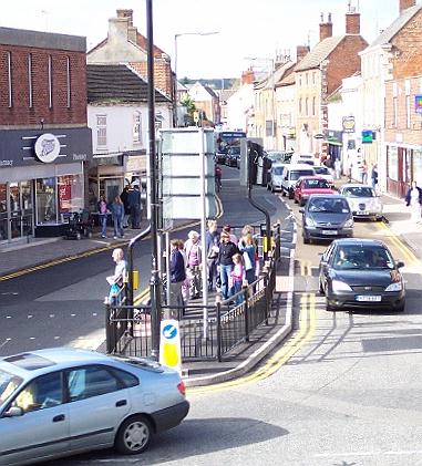
Two main roads cross in the town centre at Bourne and in the absence of relief roads or a bypass, all traffic must pass this way either on the A15 from north to south or on the A151 from east to west. The town centre was the market place in years past, the hub of the community, scene of sheep fairs, processions, regimental marches and various gatherings, not least the celebrations to mark Queen Victoria's Diamond Jubilee in 1897 and the proclamation of King George V from the steps of the Town Hall in 1910. Today, it is difficult to cross the road at this point and traffic fumes are a health hazard.
The building and maintenance of our roads during the 19th century was the
responsibility of the Vestry Meeting and it was not until 1873 that
surveyors of highways were employed to ensure that they were kept in good
order. The first were John Gibson and Charles Eldred who were appointed on
Monday 24th March. The clerk, Mr John Bell, told the meeting: "So great a
length of road now has to be maintained by the parish that it is desirable
for efficient and paid surveyors to be appointed and they will be
responsible for the roads being kept in a proper state of repair which is
not the case at present." It was a casual approach to a mounting problem
because their work was part time, both businessmen busy with their own
affairs, Mr Gibson being a hay and corn merchant and maltster of West
Street and Mr Eldred a brick and tile manufacturer of North Road. The
Local Government Act of 1894 regularised this work by passing the
responsibility to the newly-formed local authorities which appointed
qualified highway surveyors working full time, so recognising the growth
development of the country's road system. The building and maintenance of
highways is now carried out by Lincolnshire County Council, a costly and
highly efficient operation financed by a multi-million pound budget.
They did not meet with universal approval and within a few days many people had voiced misgivings over the safety of shoppers. Bourne Urban District Council hastily arranged a meeting with the engineers and told them that changes must be made immediately because of complaints that there were no pedestrian crossing controls and this presented a very real danger, especially for children and old people, at what was becoming a very busy intersection in the town centre. After the meeting, the chairman, Councillor Percy Wilson, was most emphatic about the hazards involved. "Three-fifths of the children from Bourne Primary School have to use the crossings and they do not know where to cross", he said. "A traffic warden and local police have to help them. If people try to cross in West Street, they are likely to encounter traffic coming from South Street. We left the engineers in no doubt that their installation was not what we were led to believe. We are quite dissatisfied with the arrangements relating to the traffic lights and the pedestrian crossings are lethal. They are death traps. The flow of traffic must take second place to the safety of our people, especially the young and the old. Safeguards for them are uppermost in our minds." Alterations to the system were eventually made but there was still criticism that the traffic lights in the town centre have outlived their usefulness and should have been replaced by a mini roundabout which would give a right of way to all traffic from the right. Such systems are now operating in all major towns and cities in Britain, and even in Bourne at other less sensitive spots such as West Street at the junction with Exeter Street, and in North Street at the junction with St Gilbert's Road and Meadowgate. It is believed that a similar arrangement in the town centre would ease vehicle flows and prevent the traffic jams that have become a common occurrence in recent years, and that this point has been amply demonstrated by the many failures of the lights in recent years when traffic flows continued smoothly and with little delay.
Pedestrian crossing points around the intersection were fitted with rotating tactile cones to allow the visually-impaired know when it is safe to cross while other improvements included high friction anti-skid surfacing on the approaches to the lights. Kevin Brumfield, the county's area highways manager, said that despite periods of heavy rain, the work had gone very smoothly and had been completed two weeks earlier than anticipated. "It is designed to make the area safer for pedestrians as well and improving the operation of the lights and we now have proper crossing points for the elderly and disabled", he said. There were also attempts during the 1970s to move the market off the streets because of the dangers being created by stalls erected alongside the pavements in North Street and West Street, so narrowing the space available for passing traffic although it was to be several more years before this was to become a reality. But it was obvious at this time that buses could not continue to use the Market Place as their terminus and so the construction of a new bus station was undertaken. The chosen site was at the corner of St Gilbert's Road and North Street and the new facility came into use in the autumn of 1974 and although it meant a longer walk for bus passengers arriving in town for a day's shopping or business, it was an obvious and rational development. Shortly before Christmas the following year, a new town service was inaugurated with buses travelling at intervals on circuits from the bus station through many parts of the town.
The bus station is still in use, mainly by Delaine Buses, the only remaining regular daily operator in the town, and in recent years a new covered waiting area has been added together with one of the modern-style public toilets although the original waiting room is frequently vandalised and covered with graffiti despite a warning by South Kesteven District Council in May 1996 that the damage was a liability on the public purse. During the autumn of 2000, it was announced that one of the parking bays was to be removed to make room for a new supermarket development that was planned nearby and so after more than a quarter of a century, the bus station has outlived its original importance to the town.
Increasing vehicle movement through the town also threatened the Ostler memorial drinking fountain that had been standing in the market place for 100 years because it was creating a danger to passing vehicles and in 1960 it was moved to the seclusion of the town cemetery. Since then, the number of vehicles passing through Bourne has increased annually and the current traffic light system often appears to be totally inadequate, causing long tailbacks in all directions and annoying delays for drivers. On those occasions when the lights have failed and the roundabout system of giving way to traffic on the right was implemented, there were calls for this method to be introduced permanently but it was not given serious consideration by the county highways authority. A double bend in South Street, the main road leading out of Bourne on the A15, is acknowledged as the major accident black spot for the town and yet has commanded little attention from the highways authorities over the years, a responsibility that now rests with Lincolnshire County Council. This spot, overlooked by the Abbey Church, was the scene of yet another bad accident on Wednesday 12th June 2002 when a 38-tonne articulated refuse lorry crashed into a roadside cottage, No 31 South Street, demolishing part of the outside wall and sending rubble crashing down into the street below where children had been walking past just moments earlier.
There have been many other accidents here over the years, one of the worst in 1989 when a Royal Mail lorry ploughed into the same cottage, which is a Grade II listed building and stands immediately on the bend, and five years ago a car suffered a similar fate. There have also been fatalities, the most recent in October 1998 when a van driver was killed on the corner as he drove into Bourne. UPDATED NOVEMBER 2005 See also The south-west relief road Delaine Buses Lost Cottages Dr John Gilpin Early days on the road The water cart Bourne Conservation Area - 4
Go to: Main Index Villages Index |
||||||||