The Car Dyke
The waterways of fenland have been used by its inhabitants for centuries, even as far back as the Bronze Age which is usually dated in Europe from 2000 to 500 BC. The early settlers travelled these parts by boat on their expeditions in search of fish and fowl to feed their families and for reeds to thatch their houses and turf to fuel their fires. Their boats were hewn from the trunks of oak trees and many have been found in South Lincolnshire. One of them which was recovered from Deeping Fen was 46 feet long with a maximum beam of 5 ft 8 in and had a ribbed floor and an external keel cut out of the solid wood which demonstrated that these people were no mean sailors. There is however no evidence that the early inhabitants of the fens used these waterways for anything more than domestic purposes but with the coming of the Romans 2,000 years ago, all this changed and the invaders made a determined effort to improve their lines of communication. Their most ambitious project was the Car Dyke, a watercourse of 75 miles in length, starting at Waterbeach in Cambridgeshire then crossing the River Welland and entering Lincolnshire at Deeping St James. From here, it skirted the western limits of the fens and joined the River Witham at Torksey below Lincoln, and so extended for a distance of 56 miles through Lincolnshire. The name Car Dyke, or Kárr's ditch, was originally
Karesdic, derived from Kárr, meaning a low place or fen and the Old Norse
dík and by the early 12th century had become Karisdik, then Carisdik and by 1259 it was known as
Cardik and this has led us to the Car Dyke we know today although less frequently it is spelt as Carr Dyke. A contemporary canal, the 11-mile long Foss Dyke, linked the rivers Witham and Trent and with further navigable stretches of waterway east of Peterborough along a stretch of the River Ouse known as the Old West River and to the River Cam at Waterbeach in Cambridgeshire, the system provided a lengthy and continuous chain for inland water transport from Cambridge to York. By this means therefore, supplies could be carried by barge from the fens to Lincoln and then as the army moved north, the system was extended to York by means of the Foss Dyke, the River Trent, the Humber and the Yorkshire Ouse.
A study of the canals built by the Romans in France and Germany, especially at the mouth of the Rhine, indicate that work of a similar character was probably organised by their army in Britain which resulted in the Car Dyke. Excavations carried out in 1949 along the eight-mile stretch between the rivers Cam and Ouse in Cambridgeshire showed it to be about 28 feet wide and flat bottomed. The sides sloped outwards to give a width of about 45 feet at ground level and it was about seven feet deep. These measurements compare well with those of modern barge canals. Severe fen flooding in 1947 brought water back to the Car Dyke and gave some idea of its appearance in the Roman period.
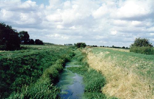
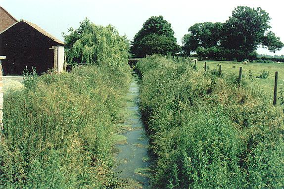
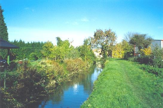
However, there is no doubt that the Car Dyke also functioned as a catch-water drain, carrying off the water from the numerous high land brooks and streams from the west and although this strategic planning soon fell into disrepair in the fifth century once the Roman administration ceased, it did begin the long process of draining the fens. This project continued in various stages, through the Middle Ages with the establishment of the Commission of Sewers to oversee the upkeep of embankments and the cleaning of watercourses, the piecemeal improvements of the 16th and 17th centuries, major work during the 19th century, particularly in 1846 when a section of the dyke north of Haconby was scoured out and deepened to improve drainage, and thence into modern times. This important waterway ran through the Bourne area and a branch canal between Bourne and Morton
still exists today but can only be seen from the air when the field crops are at a stage which make its outline visible
although it has shown evidence of soak ditches parallel to the canal to take water from the field ditches and discharge it into the canal. Much of the dyke is now silted up and disused although some of the best remaining stretches can still be seen in the Bourne area where farmers have kept it in good order for drainage and irrigation purposes, from the significantly named hamlet of Dyke and Car Dyke Farm in the neighbouring parish of Morton, to Thurlby further south but then, as the fens proper begin, it is often difficult to trace. The Heritage Trust of Lincolnshire has an ongoing research project into the origins of the Car Dyke and what the future holds but their assessment of its current state is not good. They report that the waterway still plays a role in modern farm drainage and survives in various states of preservation along its length and although ten sections have been protected as scheduled ancient monuments its future is still threatened by commercial development and intensive agricultural practices. Their aim is to stimulate public interest in the waterway both locally and regionally and to improve the access to and awareness of one of Lincolnshire's major Romano-British monuments.
Go to: Main Index |